IPAD
International
Production
Assessment
Division
Toggle navigation
Reports and Briefs
Commodity Intelligence Reports (CIR)
World Agricultural Production (WAP) Circulars
Geospatial Data
Crop Explorer
Commodity Explorer
Global Agricultural Monitoring (GLAM)
Global Reservoirs and Lakes Monitor (G-REALM)
Global Agricultural & Disaster Assesment System (GADAS)
Geotag Photo Gallery
Tropical Cyclone Monitor
WMO Station Explorer
Crop Calendars and Production Maps
Country Summary
Crop Calendars
Crop Production Maps
Monthly Crop Stage and Harvest Calendars
Monthly Production and Trade Maps
Other Global USDA Reports
World Agricultural Supply and Demand Estimates (WASDE)
USDA Weekly Weather and Crop Bulletin (NASS/WAOB)
PSD Online
FAS Attache GAIN Reports
PS&D Market and Trade Data
Help
About Us
FAS Home
/
IPAD Home
/
Crop Explorer
/
Commodity Explorer
/
Wheat Explorer
/
Nigeria
Wheat Explorer
Toolbox
Home
Return to Commodity Page
Most Recent Data
Country
European Union
Angola
Bangladesh
Benin
Brazil
Burkina Faso
Cameroon
Canada
China
Egypt
Ethiopia
Iran
Iraq
Japan
Kenya
Madagascar
Mexico
Mozambique
Nepal
Niger
Nigeria
Saudi Arabia
Somalia
South Africa
Turkey
United Arab Emirates
United Kingdom
United States
Venezuela
Vietnam
Yemen
Precipitation
Moving Precipitation and Cumulative Precipitation (Pentad)
Temperature
Average Temperature
Maximum Temperature
Minimum Temperature
Soil Moisture
Soil Moisture (CPC Leaky Bucket)
Percent Soil Moisture
Surface Soil Moisture
Subsurface Soil Moisture
Vegetation Index
NDVI (MODIS-Terra)
Additional Resources
Area, Yield and Production
WAP Production Briefs
Commodity Intelligence Reports
Country Summary
Geotag Photo Gallery
Crop Calendar
Crop Production Maps
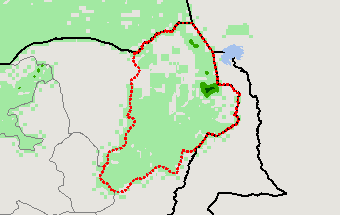
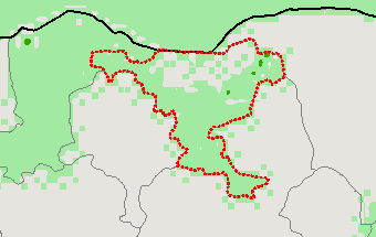
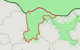
Wheat Production
2021 Long Rains (Mar - Dec) — (Last Chart Updated on 02/04/2024)
Subregions:
Select a Subregion
Borno
Jigawa
Katsina
Borno
(67% of total wheat production)
Jigawa
(17% of total wheat production)
Katsina
(7% of total wheat production)
Stay Connected
FAS on Twitter
Get Email Updates
FAS Home
USDA.gov
Economic Research Service
World Agricultural Outlook Board
Plain Writing
Trade Links
FOIA
Accessibility Statement
Privacy Policy
Non Discrimination Statement
Information Quality
USA.gov
White House