|
VALIDATION
Validation of the satellite radar altimeter measurements is performed via comparison with ground-based gauge data. Where possible, a gauge site closest to the satellite overpass is chosen and mean daily stages are compared to the relative altimetric height variations.
Because gauge data is difficult to access in many countries, case studies are often performed on lakes and reservoirs in North America. The following are examples for the GRLM lake products, In these cases, the altimetric lake levels are shifted in the y-axis (a constant offset)) to produce a best match with gauge stage values and the standard deviation of the mean offset recorded as an estimate of the overall altimetric error on the time series.
The rms errors can vary depending on the size of the lake and the complexity of the surrounding topography, as well as the roughness of the lake surface (altimetric range resolution) and knowledge of the various corrections that are performed to obtain 1 single altimetric height value on the lake. The rms values can range from better than 5cm for the large open lakes, to 15-20 cm for smaller more sheltered lakes, to many tens of centimeters for reservoirs situated in deep valleys where the instrument only observes a narrow expanse of water.
Note that the satellite technique relies on averaging to reduce the noise on a single height measurement. There is both averaging within the instrument footprint (hundreds of metres to several kilometers in diameter) and in the along-track satellite direction. The process of obtaining lake products also includes an averaging of valid height measurements along the ground track, between near and far shorelines (bank to bank). The validation exercises are thus comparing a set of averaged altimetric heights with respect to an arbitrary reference datum (the datum being specific for each lake and based on the mean height profile across the lake over a 9yr observation period) with averaged (over 24hrs) gauge stages taken at a single (latitude, longitude) location and based on a local datum or mean sea level.
See the References Section for articles and journal papers that examine the accuracy of altmetric heights over inland water bodies.
Examples
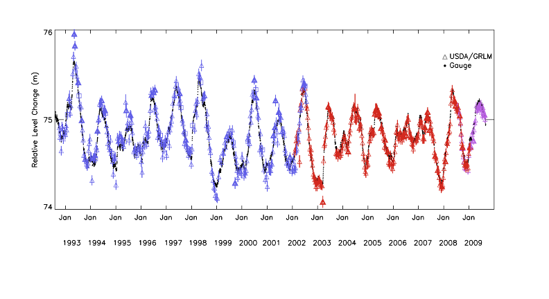
Validation of the combined GRLM lake product (TPJO.1 which are the Topex/Poseidon, Jason-1 and OSTM measurements) for satellite pass120 over Lake Ontario using daily gauge data at Rochester. Altimeter data are colored symbols, gauge data solid circles, time period 1992-2009, rms=7.65cm. Gauge data courtesy NOAA at http://tidesandcurrents.noaa.gov/station_retrieve.shtml?type=Great+Lakes+Water+Level+Data
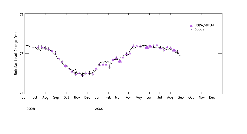
Validation of OSTM pass 120 GRLM measurements for Lake Ontario at Rochester using daily mean gauge data. Time period 2008-2009, rms =4.37cm, gauge data courtesy of NOAA.
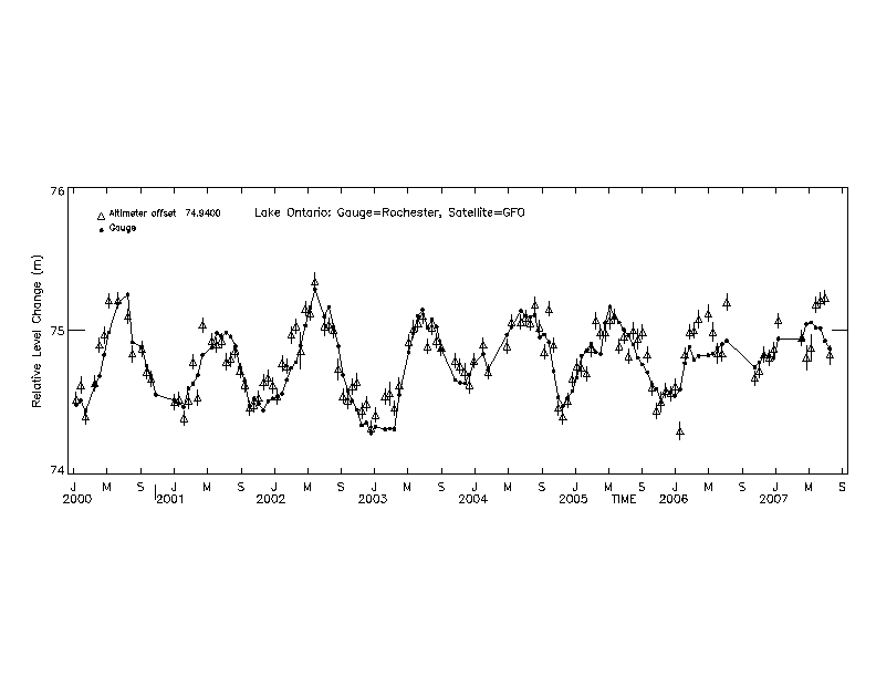
Validation of GFO pass155 GRLM measurements for Lake Ontario at Rochester using daily mean gauge data. Time period 2000-2007, rms=13.69cm, gauge data courtesy of NOAA.

Validation of preliminary Topex/Poseidon and Jason-1 pass178 GRLM measurements for Lake of the Woods, USA with daily mean gauge data. Time period 2002-2003, rms=26.1cm (outliers removed), gauge data courtesy of USGS, figure courtesy of Ross and McKellip, 2006.

Validation of preliminary Topex/Poseidon and Jason-1 pass002 GRLM measurements for Lake Powell, USA, with daily mean gauge data from the Glen Canyon Dam. Time period 1992-2003, rms=140.6cm (outliers removed), gauge data courtesy of U.S. Bureau of Reclamation, figure courtesy of Ross and McKellip, 2006.
|
