BURMA: Widespread Cyclone Damage in Major Rice Production Regions
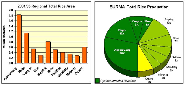
Cyclone Nargis, a category-3 tropical storm, struck the low-lying and heavily populated Burmese coastline on May 2nd with winds of 132 miles per hour. The storm had sufficient strength to propagate a 12 foot tall sea wave (storm surge) that inundated vast areas of farmland in at least 4 major rice producing Divisions (provinces). The storm surge was estimated to have affected a 2000 square mile area with a population estimated by the United Nations of 24 million, including major portions of the divisions of Ayeyarwady, Yangon, Bago, and Mon. These 4 divisions collectively account for 58 percent of the national rice crop, or roughly 6.2 million tons on a milled basis. USDA flood impact analysis from cyclone Nargis indicates that approximately 1.75 million hectares of rice producing land was inundated with salt water, and remains flooded at this time. This represents 30 percent of total wet season rice area in the country. In addition to the inundation, large numbers of villages were destroyed along with much of their foodstocks, livestock, and farming supplies. It is unknown at this time what actual impact the current damage and disruption will have on the country’s rice production capacity in 2008/09, but it is clear that the government and rural farming population have many significant problems to overcome to recover from the cyclones devastation. The storm surge which swept through huge swaths of low-lying farmland was unimpeded by any natural ecological barrier, such as mangrove forests. The lower Ayeyarwady delta had once been densely populated with mangroves, offering some natural protection from severe storms and oceanic waves. However, researchers indicate that 83 percent of all mangroves in the region were cleared or destroyed between 1924-1999, as the region was developed for rice agriculture. British colonial authorities originally fostered large-scale settlement and agricultural development in the region, and this pattern continued following independence in 1948 as rural populations grew. The few remaining mangrove forests in tidal areas of Burma today continue to dwindle, as both rural and urban populations rely on them for their main source of firewood and charcoal.
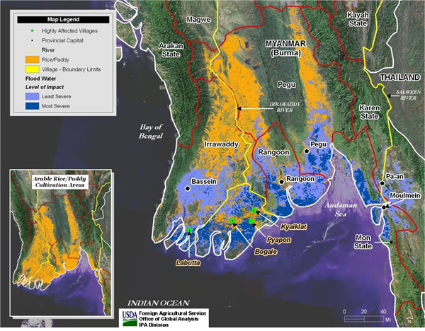
Cyclone Nargis Flood Inundation Analysis Map: May 2008
Production Environment
Burma produces two rice crops annually, the first in the summer monsoon season (wet season) and the second in the winter months (dry season). The International Rice Research Institute (IRRI) indicates that the planting period for the main wet season crop is from June-August, with the harvesting period from November-January. They also indicate that the planting period for the dry season crop is from November-December, while the harvesting period is from April-May. The summer wet season crop primarily relies on heavy monsoonal rains, whereas the dry season crop is irrigated. Wet season production typically accounts for 85 percent of total production, with the dry season the remaining 15 percent. Burma has made efforts over the past 10-15 years to increase overall rice production by expanding acreage during the dry season when much of the arable land is fallow. Current estimates of irrigated area vary between 1.5-2.0 million hectares. Much of this is focused in the prime rice growing regions of the Ayeyarwady delta, but also in the drier northern growing regions of Mandalay, Sagaing, and Bago Divisions.
According to an exhaustive study of Burma’s rice sector by the Arkansas Global Rice Project (An Economic Assessment of the Myanmar Rice Sector: Current Developments and Prospects; 1998), there are 4 main types of rice ecosystems in the country. Lowland rainfed crops make up about 52 percent of total rice area; deepwater submerged rice 24 percent; irrigated lowland rice 18 percent; and rainfed upland rice 6 percent. Both the lowland rainfed and deepwater submerged rice areas are primarily situated in the lower Ayeyarwady delta region consisting of the Ayeyarwady, Yangon, and Bago Divisions which experienced significant damage from Cyclone Nargis. Given the majority of the rice crop in this region is rainfed, most fields are designed to capture and store rain water, with bunds (embankments) surrounding the field boundaries. The Arkansas study also points out that lowland rice is typically transplanted from seedling nurseries and that the rice plants are kept partially submerged by rainfall, irrigation, or natural flooding for the entire growing season. Farmers typically plant rice varieties of varying growth periods to spread out their planting and harvest activities over a period of months, and to guard against unfavorable or unpredictable weather. Rice varieties offering short (100-150 day), medium (150-170 day), or long season (170-200 day) characteristics are commonly available. Mechanization of rice farming operations is extremely limited, use of fertilizers is very low, and labor in many areas is also in short supply during peak need. Farmers generally own a pair of draft animals to perform all rice field preparation work (plowing, harrowing), grain threshing, and transporting rice to market.
Rice Production Situation
The current 2008/09 rice production season is just beginning in Burma, with planting operations for the main wet season crop usually underway in June. Widespread establishment of rice seedling nurseries to supply the early sown crop should have been accomplished prior to the arrival of cyclone Nargis. Losses of nursery stock from wind and wave action or saltwater intrusion is expected to have been significant. Young rice seedlings are particularly sensitive to saltwater, and will have had high mortality rates in inundated areas. Given that the flood-affected region is also the most concentrated rice production area of the country, planting operations are expected to be delayed if not entirely curtailed in some of the worst-hit areas. This is especially true in the lowlands of Ayeyarwady Dvision where the storm came ashore, and where extensive loss of life occurred.
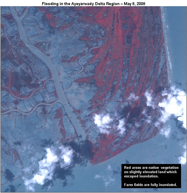
USDA flood impact analysis concluded that about 30 percent of the nation’s wet season rice area, or 1.75 million hectares, was inundated by the storm surge accompanying cyclone Nargis. The Divisional breakout of flooded rice land is as follows: Ayeyarwady 800,000 hectares, Yangon 450,000 hectares, Bago 250,000 hectares, Mon 250,000 hectares. The inundated region is capable under normal conditions of producing approximately 4.6 million tons of rough rice (paddy) or 2.7 million tons of milled rice. USDA’s analysis incorporated the use of Landsat satellite-derived rice area data, compiled using 30-meter resolution imagery (Geocover 2000). It also utilized pre-and-post flood MODIS satellite imagery from the NASA Terra satellite. This flood data was at 250 meter resolution. The combination of these datasets allowed the flood impact on known rice cultivation areas in Burma to be estimated. On May 14th the United Nations Food and Agricultural Organization (FAO) reported that Burma’s Ministry of Agriculture had estimated that roughly 1.6 million hectares of rice fields were damaged by cyclone Nargis, with many of the fields inundated with salt water. It is not known how their estimate was determined, but it does confirm USDA’s assessment.
Rice production in 2008/09 is expected to be hampered in the inundated region for a variety of reasons. Foremost of these is the matter of salt water intrusion on a very significant scale. Saltwater is a serious problem for rice cultivation, and affected fields will have to be drained and flushed with sufficient fresh water before normal cultivation can be considered. Unfortunately, drainage may be a problem even in areas where loss of life in the local farm population was light, owing to the fact that the rice fields themselves are designed to store available water. Extensive land areas will need to be drained and reclaimed using fresh water sources that may in fact be quite limited. Reclamation efforts on the scale indicated by the inundation map would require considerable national resources and organization. It is uncertain to what degree the government is in a position to carry out or assist in such activities, and how quickly such work can be accomplished. Heavy rainfall is expected to arrive in the region in coming weeks, but it is unknown whether rain itself will provide sufficient aid in diluting the salt levels in inundated fields or in flushing salt water from affected soils. The FAO announcement also indicated the government was seeking international financial aid to acquire 6,000 tons of seed of salt-tolerant rice varieties, which would provide the capacity to sow about 100,000 hectares of rice in areas with the worst saline conditions. However this amounts to only 6 percent of the inundated region, and it is unclear whether this will be anywhere near adequate or not. Depending on the level of salinity in farmer’s fields and the length of time rice is exposed to salty conditions, the net effect on the new rice crop will be quite varied. At low salt levels rice can be grown but the net result will be lower plant populations (less than normal stand density). At slightly higher levels the rice plants will have reduced grain yields. And at very high levels, rice shouldn’t be grown at all. Researchers indicate that farmers whose fields cannot be flushed with adequate fresh water, but only have moderately low salinity levels, can increase their seeding rate by 10-20 percent to try to overcome the problem of thinning plant populations.
Another issue is the death and dislocation of major human and livestock populations which are required to cultivate a normal crop this year. It is unknown at this time what actual capacity farm families have to recover quickly, given a lack of accurate assessments about the status of basic needs such as food, shelter, drinking water, and farm supplies in the region. It is evident from news reports that extensive numbers of villages were decimated in the inundated rice producing region. However, if U.N. estimates are correct, then only 7-10 percent of the total rural population in the affected areas, or 1.6-2.5 million people, have either died or been displaced by the storm. This implies that a large majority of the regional population survived the storm, and can continue farming if adequate food and farm supplies are available. The FAO report indicated that the cyclone ravaged region was famous for livestock production, and that an estimated 200,000 water buffalo and cattle were killed in the storm. These draft animals were crucial to the regions rice cultivation capacity. Given most farmers owned two cattle to carry out normal farm operations, the loss estimated by FAO implies that roughly 100,000 farms are without draft animals to plant the 2008/09 main season rice crop. Given the average farm size in the delta region is 3-4 hectares; the impact of the cattle’s demise could reach a total of 400,000 hectares of rice land.
One of the primary post-storm concerns has to do with how much of the existing commercial and on-farm rice storage in the region was lost due to destruction and inundation, or has deteriorated owing to these conditions. The cyclone affected region produces on average about 60 percent of national rice production, with the major population center of Yangon as a focus of urban foodgrain demand. With an estimated population in the region of 24 million, there must have been a sizable amount of rice stored in villages, at local and regional milling facilities, and in bulk warehouses. Over 11.0 million tons of paddy (6.2 million tons milled basis) were harvested in the region since November, with the vast majority of that needed for local consumption. Milling and grain warehousing authorities are known to store bulk paddy rice, as well as processed or milled rice for lengthy periods. Given the 2007/08 dry season harvest was in its final stages of completion when cyclone Nargis hit, it is likely that a sizable portion of that harvest was still held locally in areas devastated by the storm. The Arkansas study mentioned above indicates that farm families store their paddy for annual home consumption for a period of 5-9 months on average. Traditional storage facilities are called “pokes” and consist of a circular bamboo bin which is sealed with cow dung and mud. These bins would have been subject to widespread damage from cyclone Nargis’s high winds and the resulting storm surge wave and subsequent inundation. This also implies that a significant amount of farmer’s food grain stocks and rice planting seed may have been lost, damaged, or is possibly deteriorating owing to excessive moisture conditions. Anecdotal reports from the storm-affected region also indicate that rice mills and warehouses were damaged or destroyed, especially in the worst-affected townships of the Ayeyarwady Division. Given adequate post-storm organization, transportation, and redistribution capabilities, it is likely that adequate planting seed could be made available for the upcoming planting season, but whether it will be made available on a timely basis is questionable. Burma’s Ministry of Agriculture reported that it is seeking aid to purchase a total of 50,000 tons of rice planting seed for the upcoming wet season crop. This indicates the government is aware of large-scale losses of on-farm supplies of rice seed, as it is trying to secure a quantity capable of planting a significant portion of the affected region. Whether or not there is adequate rice in the region to supply the food needs of the population is another matter. The next rice harvest is 6-8 months away, and its potential size is already in question.
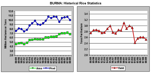
As of May 2008, USDA is estimating Burma’s 2008/09 rice production at 10.0 million tons (milled basis), down 0.7 million or 7 percent from last year. Rice area is estimated at 6.8 million hectares, down 0.29 million or 4 percent from last year. USDA will be evaluating all available information over the coming weeks concerning possible damage to rice production capabilities, and planting prospects. Revised production estimates will be made available when more detailed assessments have been completed.
Current USDA area and production estimates for grains and other agricultural commodities are available on IPAD's Agricultural Production page or at PSD Online.
|