Estimated 2010/11 Grain Production In Tunisia Falls 50 Percent from Last Season;
Crop Travel Confirms Precipitation Missed Central and Southern Agricultural Regions
Agricultural specialists from FAS traveled through Tunisia during early April 2010 to visit fields, speak with farmers, and to meet with various agricultural specialists in the public and private sectors about the current conditions and situation and learn about issues facing grain production in the country.
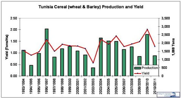
Tunisia's grain production, like the other Northwest African countries: Morocco and Algeria, is almost exclusively wheat and barley, so it is common to see a combined grain (wheat and barley) figure release in the press. USDA estimates Tunisia's 2010 total wheat and barley crop at 1.2 million tons, down more than 50 percent from last year's bumper crop and also down 33 percent from its five-year average. Yield is estimated at 1.28 tons per hectare, the lowest in several years. Harvested area is estimated at about 1.0 million hectares, compared to its 1.2 million hectare five-year average. More specifically, wheat production is estimated at 0.9 million tons from 0.7 million hectares. This compares to a five-year average of 1.3 million tons from 0.8 million hectares. Barley is estimated to be 0.3 million tons from 0.3 million hectares. Tunisia is typically the smallest grain producer in the grain-deficient Northwest Africa region. Depending upon weather conditions, Tunisia normally produces between 15 and 25 percent of the three-country's combined grain crop.
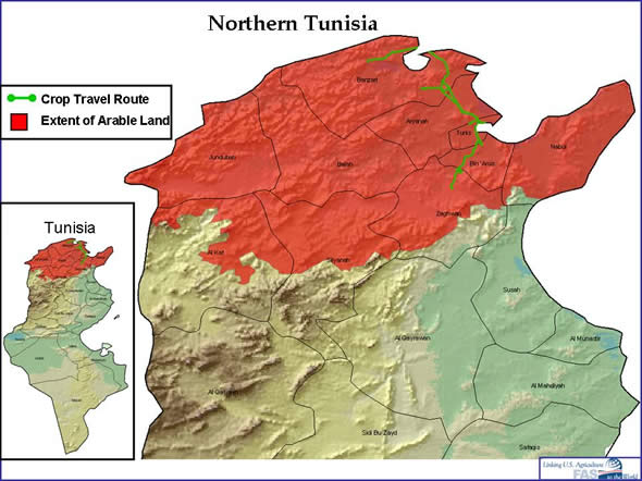
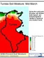
During autumn 2009 through spring 2010, Tunisia experienced storm systems that consistently skirted the northern coastal areas but failed to penetrate southward to relieve the large, central grain belt's dryness. Although Tunisia’s central agricultural region is climatically drier than its Mediterranean Coast, this season's winter and spring rainfall amounts only exacerbated the north-south precipitation differences. Below the coastal governorates, almost no rain fell from December through February. The northern areas received considerable rainfall in March and all agricultural areas enjoyed increased rainfall in April. In the northern coastal jurisdictions: Jendouba, Beja, Bizerte, and Ariana, the wheat crop was seen or reported to be in very good condition in early April. However, not far south, fields were in poor or very poor condition due to lack of moisture in Zaghwan and Ben Arous Governorates.
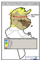
 The smallest of the Maghreb countries (Morocco, Algeria, and Tunisia), Tunisia has a very diverse climate that changes rapidly from north to south. The country is elongated in a north-south direction, with arable land comprising only the northern fraction of the country. The land along the Mediterranean Coast and the land in the west near the Algerian border typically have the most rainfall and the highest yields. These areas are the most humid because of their close proximity to the sea, their geographic location which coincides more frequently with the southern edge of prevailing storm tracks, and a higher elevation near the Algerian border. In the north, farmers are subjected less to the rainfall variances that are more common in most of Northwest Africa’s grain regions. The climatic zones transition rapidly from north to south through semi-humid, semi-arid, arid, and finally desert regions. Ultimately, some storm systems traveling west to east out of Morocco and Algeria do not extend far enough south to reach Tunisia’s central growing region. The smallest of the Maghreb countries (Morocco, Algeria, and Tunisia), Tunisia has a very diverse climate that changes rapidly from north to south. The country is elongated in a north-south direction, with arable land comprising only the northern fraction of the country. The land along the Mediterranean Coast and the land in the west near the Algerian border typically have the most rainfall and the highest yields. These areas are the most humid because of their close proximity to the sea, their geographic location which coincides more frequently with the southern edge of prevailing storm tracks, and a higher elevation near the Algerian border. In the north, farmers are subjected less to the rainfall variances that are more common in most of Northwest Africa’s grain regions. The climatic zones transition rapidly from north to south through semi-humid, semi-arid, arid, and finally desert regions. Ultimately, some storm systems traveling west to east out of Morocco and Algeria do not extend far enough south to reach Tunisia’s central growing region.
Wheat dominates Tunisia’s northern agricultural areas, while barley is more common further south. Culture and history, however, play a large role in crop selection. Common and durum wheat can be found almost everywhere within Tunisia's agricultural areas, but climatically, farmers should probably avoid the crop in the drier central areas. Barley is better suited for the dryness and is grown in large amounts from south of the capital Tunis, to the northern side of the low mountains that extend across the north-central part of the country. South of this line, almond and olive trees become the dominant crops. Practically all the arable land in Tunisia lies within 100 miles of the Mediterranean Coast, and the best agricultural lands (comprising the wheat belt) easily fit into the northern half of that.
In the central growing region, unlike the farmers in the north, farmers will often wait until after fall rains arrive before sowing their fields. This central area is dominated by barley because of its better tolerance for dryness and it adaptation to poorer soils. Because of the unreliability of rainfall in this region, forgoing early plantings to ensure that crops will have enough soil moisture to germinate is a calculated, necessary delay. In Tunisia’s central region, farmers typically use last year’s seeds, and add few or no inputs. They minimize their costs as a safeguard against a poor crop. Their major fear is to have spent a significant amount of money on a crop that will fail anyway, because the weather is not conducive to grain production. This is an area largely of subsistence farming.
Typically rain arrives to Tunisia in October, but it can start anytime from September through December. In the north, famers tend to plant during November whether rain has arrived or not. There is confidence of the arrival of planting rains so fields are sown by the calendar and not restricted until after the rains arrive. Flowering usually occurs in March, with the harvest following in June and July. Barley harvest begins earlier, starting in May. April is one of the most critical months for moisture because plants are in the grain-fill stage and need water to boost grain weight. An inch to an inch and a half of rainfall during April is sufficient to ensure good yields from a well-established crop. While April 2010 rains probably came close to achieving the one inch threshold, significant and irreversible damage had already occurred to a significant portion of the crop because moisture was not present during the earlier phases of plant development.
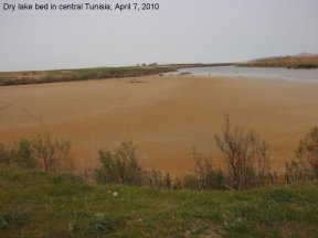
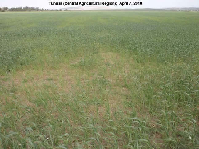
The odds quoted by farmers of reaching a good crop in central Tunisia are not encouraging. It’s a significant gamble. A couple different producers quoted the same ratios: Out of 10 years, 5 will be bad years, 3 will be average, and 2 will be good years. Because of the reduced costs for production in these more marginal lands; however, farmers in this region have a low break-even point – some said it lies at 0.5 tons per hectare. Rainfall dictates almost every decision of the cereal farmer in central Tunisia. The farmer in this area must frequently re-evaluate the situation as the season reaches critical points. If additional rain arrives, it may make sense to apply or to increase input amounts to enhance yield or quality. If rainfall doesn't improve, there is little incentive to improve yields with costly fertilizers, herbicides, fungicides, or insecticides. They must often make a very tough, strategic decision in April: Whether to grow their crop until it reaches harvestable grain, cut it into silage, or simply allow animals to graze it off as in the picture associated with this link. Rental costs, fuel costs, animal needs, and weather forecasts all become part of this very important and irreversible decision.
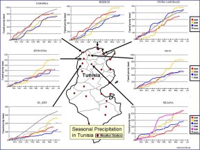
Satellite data confirms the field observations mentioned earlier. The satellite-derived maps linked below, depict higher-than-average NDVI values in Morocco and Algeria, while lower values are concentrated in central Tunisia. These maps are comparisons to average levels and represent where vegetation is doing better or more poorly than normal. The first map includes all vegetation areas of Northwest Africa and the second map concentrates on the dominant crop areas in Northwest Africa. Both maps depict a very good crop growing in Morocco and Algeria, but a very poor crop in central Tunisia. In addition to the MODIS Satellite derived maps, there are two images showing how the crop area's vegetation health appears in comparison to other seasons. The NDVI charts show the 2010/11 marketing year crop in red (grown in 2009-10) in a northern crop governorate as well as two governorates in the central region. Higher NDVI values tend to correlate with more vegetation vigor and also higher yields. The MODIS NDVI charts show that the NDVI in Banzart, Tunisia's most northern jurisdiction, peaked at the second highest level in six years, while the 2010/11 crops in the two central jurisdictions have the lowest NDVI "peak" of the past six years.
Tunisia's farms average less than 5 hectares, and about 85 percent of the farmers produce only for their own consumption. While the vast majority of farmers have just small non-marketable production, farms of 100 hectares or more do exist. These are the producers who sell their wheat to the government or traders. There is reportedly 0.5 million tons of quality grain storage capacity. Much of the on-farm storage facilities are not high-quality facilities and can experience high loses.
The government has announced a goal of reaching a national grain production level of 2.7 million tons annually. This amount is anticipated to include enough common wheat to meet self-sufficiency demands by 2013. Tunisia is currently not far from being self-sufficient in durum production but common wheat production is still low compared to its consumption needs. Tunisia's durum wheat production is always the highest percentage of the Maghreb countries, comprising about 80 percent of Tunisia's wheat harvest. The government's goals include technology exchanges, increasing certified seed usage, and reaching 120,000 hectares of irrigated cereals in the short term. At present, no more than 100-110 thousand hectares of grains are under irrigation.
The USDA's June area and production estimates will be released in the WASDE and WAP reports on June 10th.
They can be found at:
http://www.fas.usda.gov/wap/current/toc.asp and
http://www.usda.gov/oce/commodity/wasde/index.htm
Some of the most recent reports on Tunisian agriculture by the US agricultural attache in Tunis include:
http://gain.fas.usda.gov/Recent GAIN Publications/Grain and Feed Annual_Tunis_Tunisia_4-19-2010.pdf and
http://gain.fas.usda.gov/Recent GAIN Publications/Oilseeds and Products Annual_Tunis_Tunisia_2-24-2010.pdf
The homepage for the FAS GAIN reports website is at:
http://gain.fas.usda.gov/Lists/Advanced Search/AllItems.aspx
The USDA's current global forecast of area and production for grains and other agricultural commodities are available on PSD Online.
|