Flooding in Northeast China - Impact on Crops To Be Determined

Fuyuan, Heilongjiang – August 26, 2013
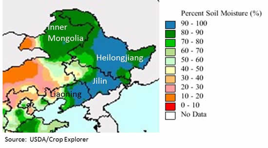
Unusually heavy rainfall (40 to 50 percent above normal) was recorded in Northeast China this summer, leading to widespread flooding and waterlogged cropland. The rain was heaviest in northern and western Heilongjiang, eastern Inner Mongolia, and the mountainous areas of eastern Jilin and Liaoning. Total rainfall from June 1 through August 20 exceeded 300 mm (12 inches) across the region, with some locations reporting more than 700 mm (24 inches). Moderate (near normal) rainfall after August 20 has kept soil moisture levels high in Northeast China and contributed to additional runoff. (Figures 1-4)
The major rivers in the region, including the Heilongjiang/Amur, Nenjiang, and Songhua all reached or exceeded flood stage by mid-August. Local officials said the flooding is the most extensive since 1998, and some locations have recorded the highest water levels in more than 100 years. There have been 85 deaths, and 105 people are still missing. Bridges, roads, fishing ports, dikes, homes, oil wells, storage facilities, and businesses have all been damaged by the rising floodwaters. (Figures 5-11).

The impact on crops is still undetermined, but preliminary estimates by Chinese sources estimate that flooding has affected more than 2 million hectares of cropland in the region. To put this in perspective, the four Northeast provinces of Heilongjiang, Jilin, Liaoning, and Inner Mongolia had an estimated 28.7 million hectares of sown area in 2011
The Northeast is one of China’s most important agricultural regions, accounting for about 42 percent, 16 percent and 45 percent of China’s total corn, rice and soybean output, respectively (2011 provincial data). Local officials have stated that despite the unusually heavy rain and flooding, overall growing conditions for summer crops have been generally positive this summer. Favorable factors include adequate sunlight, seasonable temperatures, and the lack of drought. It is said that losses caused by flooding may be offset by higher yields in areas outside the flood-impacted zones. However, there are concerns that the wet soils and high humidity will lead to above-normal incidents of disease (particularly rice blast) and insect damage, and that weather-related harvest delays could result in losses from an early frost. The impact of flooding on China’s total soybean crop, which is planted intensively in Northeast China, is likely to be proportionally greater than for corn or rice.
Flooding has started to subside in the Nenjiang River, but water levels in the Songhua and Heilong rivers remain at near-record levels. The city of Fuyuan, at the junction of the Songhua and Heilong, is bracing for a flood peak on or about August 31 that is expected to be the largest since 1984.
Weather Data
Figure 1: Total Rainfall, June 1 to August 21, 2013

Figure 2: Rainfall Graphs – January 1 through August 20, 2013
Decadal (10day) graphs show that rainfall in Heilongjiang, Jilin, and Liaoning has been above normal since the beginning of July.

Figure 3: Weekly Rainfall, August 21 – 27, 2013
Moderate, near-normal rainfall after August 20 kept soil moisture levels high in Northeast China.

Figure 4: Soil Moisture Map – August 20, 2013
Soil moisture was above 90 percent (saturation level) over most of Northeast China as of August 20, 2013, particularly in Heilongjiang and Inner Mongolica. Soil moisture levels in western jilin and southern Liaoning were close to normal. These areas often suffer from summer drought, so the current moisture levels are favorable for crop development.

MODIS Imagery
Low resolution (1 km) MODIS satellite imagery highlights the scope of the flooding now underway in Northeast China. The following image pairs show the difference between water levels in August 2012 and August 2013. The volume of water (dipicted in dark blue) is cleearly much greater in 2013.
Figure 5: Flooding on the Nenjiang River

Figure 6: Flooding on the Nenjiang River - 2013 and 2012

Figure 7: Flooding on the Amur/Heilong River

Figure 8: Flooding on the Amur/Heilong River - 2013 and 2012

LANDSAT Imagery
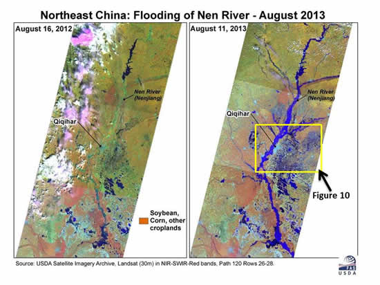
In the following medium resolution (30 m) LANDSAT images, the normal river channel and natural wetland features (from 2012 imagery) are compared to the situation in 2013.
Figure 9: Flooding on the Nenjiang River - LANDSAT comparison

Figure 10: Flooding Near Qiqihar – River and lake boundaries in 2012 indicated in yellow.

Figure 11: Close-up of Flooding Near Qiqihar:

Cropland near the river (indicated by grids) is completely covered by water, and the flooding extends far beyond the normal river channel and is barely contained within protective dikes (white lines). Cropland in the lower-right part of the image is covered by standing water. The light blue/white shapes represent built-up areas (villages and cities). Hundreds of thousands of people were forced to evacuate from their homes to avoid the flooding in the region
Current USDA area and production estimates for grains and other agricultural commodities are available on IPAD's Agricultural Production page or at PSD Online.
|

