Ethiopia Travel Report: Harvest Underway and Above-average Crop Output Expected
Harvest is underway in Ethiopia and seasonal satellite imagery products indicate above-average cereal yields are expected for Ethiopia’s main cereal crops (corn, sorghum, wheat and barley) during the December 2013 harvest. Figures 1-2 show three primary satellite-derived products (i.e., Seasonal percent of normal rainfall, Water Requirement Satisfaction Index (WRSI) Anomaly, and Actual Evapotranspiration (ETa) Anomaly) which indicate average to above-average crop conditions for Ethiopia’s 2013 crop season. Internet links to these satellite-based crop monitoring products are listed below, under the section titled “Related Internet Sites for Monitoring Crop Conditions by Satellites”.
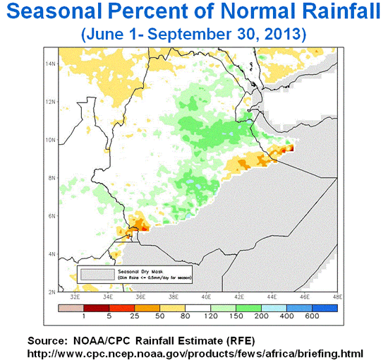
Figure 1. Seasonal Percent of Normal Rainfall
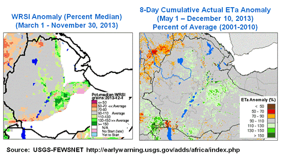
Figure 2. Water Requirement Satisfaction Index (WRSI) Anomaly
and Actual Evapotranspiration (ETa) Anomaly Products
In addition, personnel from USDA’s Foreign Agricultural Service (FAS) and USAID’S FEWSNET offices performed a four-day transect through the Amhara Region, Ethiopia from November 9-13, 2013 to compare actual crop conditions with satellite-derived observations. The transect survey team obtained general crop condition information from field observations and from 13 random farmer interviews conducted along the transect route. The GPS transect route and location of the 13 farmer interviews are shown in Figure 3.
During the transect survey in Amhara Region, special attention was devoted to the performance of the ETa Anomaly product recently developed and released by the USGS-FEWSNET office. The ETa Anomaly product from USGS-FEWSNET is a new satellite-derived product for monitoring crop conditions and it uses the MODIS Land Surface Temperature (LST) product with 1-kilometer resolution from the MODIS thermal band.
The survey team found the ETa Anomaly product is a powerful tool for crop monitoring, with its 1-kilometer spatial resolution providing many advantages over the approximate 10-kilometer spatial resolution from FEWSNET’s RFE (Rainfall Estimate) and WRSI products. In addition, the USGS-FEWSNET office has the ability to improve the 1-km spatial resolution to 120-meters spatial resolution by utilizing Landsat-8’s 120-meter spatial resolution Thermal Infrared Sensor (TIRS). The 120-meter ETa Anomaly product derived from both MODIS and Landsat-8 TIRS sensors is very useful for more detailed monitoring of crop water consumption use for both dryland and irrigated crops. The USGS FEWSNET office states their ETa Anomaly product (with current 8-day temporal coverage over Africa) will be expanded for global coverage next year. They also plan to provide an ETa Map Viewer with the ability to perform ETa time-series analysis over major cropland regions worldwide.
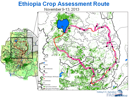
Figure 3. GPS Transect Route from November 9-13, 2013 through Amhara Region, Ethiopia
Related Internet Sites for Monitoring Crop Conditions by Satellites
NOAA’s Seasonal Rainfall from RFE (Rainfall Estimates)
USGS-FEWSNET Water Requirement Satisfaction Index (WRSI) and Actual Evapotranspiration (ETa) Anomaly Products
USDA/NASA’s Global Normalized Difference Vegetation Index (NDVI-MODIS) and Cropland NDVI-MODIS Time Series Analysis for Global Agriculture Monitoring
USDA/FAS Crop Explorer
Current USDA area and production estimates for grains and other agricultural commodities are available on IPAD's Agricultural Production page or at PSD Online.
|