IRAQ: 2015/2016 Wheat Production Favorable but Down from Last Year’s Record Crop
The U.S. Department of Agriculture (USDA) estimates Iraq’s 2015 market year (MY2015/16) wheat crop at 3.3 million metric tons (MMT). Production is down 200,000 MT, (5.7 percent) from 2014 which was a record crop. The 5-year average for Iraq wheat production is 2.87 MMT. Harvested area is estimated at 2.45 million hectares(MHa), down 10,000 hectares (Ha) from last year, with yield estimated at 1.35 MT/Ha, a 4.9 percent decrease from last year’s 1.42 MT/Ha. A record yield of 1.60 MT/Ha was achieved in 2009.
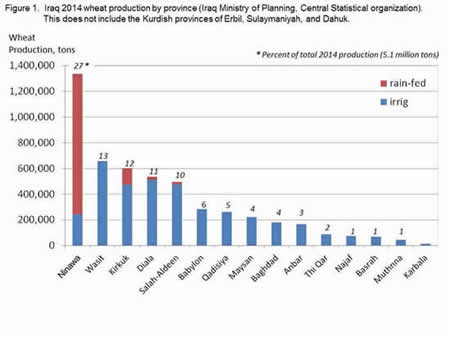
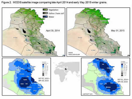
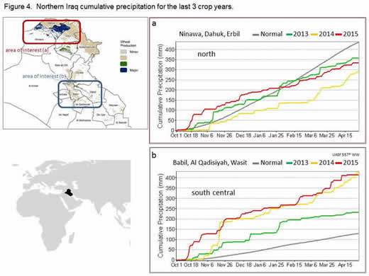
The bulk of the wheat produced in Iraq occurs in the northern provinces where much of the crop is dependent on rainfall (Fig. 1). – Kurdish provinces are not included in Iraqi Ministry of Planning Central Statistical Organization (COSIT) data. Rainfall was well distributed in 2015 between the major wheat production area in northern Iraq and southern Iraq which also produces a significant portion of the crop. The biggest boost to the 2015 crop was the more prevalent precipitation in the north as compared to last year (Fig. 2). Precipitation in the north exceeded last year and was on track with moisture levels observed in 2012 (Figs. 3a and 4a). Precipitation in the southern region was very favorable being similar to last year and well above normal (Figs. 3b and 4b).
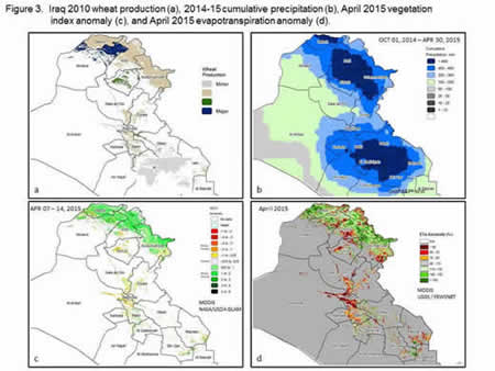
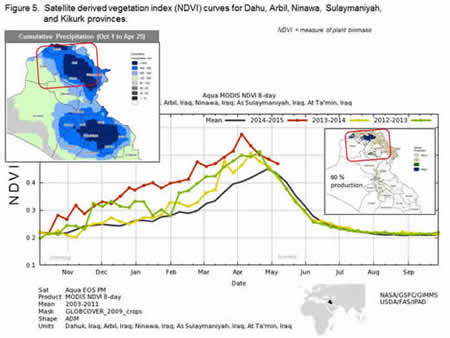
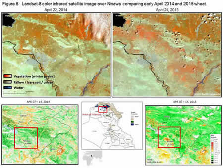
In addition to the precipitation being very favorable, the Moderate Resolution Imaging Spectroradiometer (MODIS) satellite vegetation index (normalized difference vegetation index - NDVI) anomaly indicated an above average crop in the north across the provinces of Ninawa, Dahuk, Erbil and Sulaymaniyah (Fig. 3c). MODIS NDVI curves for the northern region indicate a winter grain crop that is well above average and exceeds last year’s very good crop (Fig. 5). Landsat imagery in Figure 6 illustrates the difference between 2015 and last year in the northern winter grains surrounding Mosul. MODIS NDVI along with the Landsat-8 imagery revealed the 2015 crop to have a higher level of planted area in the north and to be more advanced than last year. In central Iraq, however, NDVI and evapotranspiration (ETa) anomalies indicated reduced crop production in the provinces of Kirkuk, Sala ad Din, Dyala, and Baghdad (Figs. 3c and 3d). These observations corresponded with reports of a reduction in planted area due to the conflict in this central region. The southern wheat growing region received beneficial rains but NDVI curves for this area did not indicate wheat production to exceed last year’s crop (Fig. 7).

Overall, the 2015 crop was found to be above average in the north, below average in the central region, and near average in the southern region. Good rain and irrigation resources, along with moderate winter temperatures, have allowed for a good growing season that, given the reduction in planting due to conflict, place the 2015 winter grains crop under last year’s record crop, but well above the 5-year average.
This report has been published by the Office of Global Analysis (OGA), International Production Assessment Division (IPAD).
Current USDA area and production estimates for grains and other agricultural commod
ities are available on IPAD's Agricultural Production page or at PSD Online.
|