IRAQ: 2015 Rice Production Drops by More than Half due to Lack of Irrigation
The U.S. Department of Agriculture (USDA) estimates Iraq’s market year (MY) 2015/2016 rice production (crop year 2014-2015) at 110,000 metric tons, down 59 percent from 267,000 tons last year. Harvested area is estimated at 48,000 hectares, down 50 percent, with rough rice yield at 3.44 tons per hectare, a decrease of 17.7percent from last year.
Most of Iraq’s rice crop is grown near the city of Najaf, which is 130 kilometers south of Baghdad, with the Euphrates River as the source of irrigation. The crop is planted into flooded fields in late June and then harvested by late November. Rice is the principal crop in the Najaf region and is important to the regional economy. Iraq’s rice production is well below national consumption and Iraq imports rice.
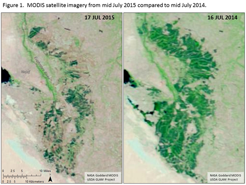
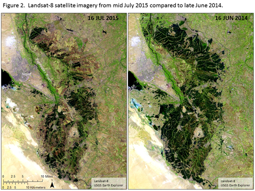
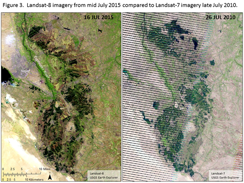
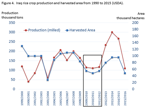
Moderate resolution imaging spectroradiometer (MODIS) satellite imagery from mid-July 2015 showed a significant decrease in vegetation from last year (figure 1). During this time fields would have rice at the seedling growth stage, and be flooded with irrigation water. The MODIS imagery indicates a much smaller flooded area for July 2015 so our area estimate is also smaller. Similar observations were obtained by comparing higher resolution (30 meter) Landsat-8 imagery collected in July 2015, and compared to June 2014 (figure 2). Many of the rice fields appear to be left fallow for the 2015 season, and the planting window for rice has now passed. A useful comparison is to the analog imagery for the 2010 rice crop (figure 3). In 2010, the lower rice area was attributed to restricted water conditions, mainly associated with dryer weather and low river flow. The low flow years of 2009 to 2011 affected Iraq’s rice production as well (figure 4).
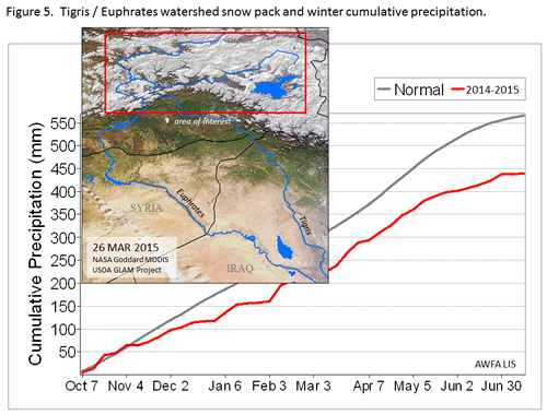
Water for the Euphrates River comes from precipitation that falls in northeastern Turkey, which provides nearly 90 percent of the total original flow. Cumulative precipitation over the Euphrates recharge area was steady this year and although 20 percent below normal the snow pack, based on MODIS imagery from the end of winter, appeared to be adequate and would not support concerns for a drought (figure 5).
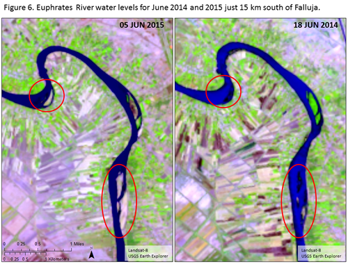
Turkey has a series of dams along the Euphrates as part of the massive Güneydoðu Anadolu Projesi irrigation project (GAP). The project has been controversial because of low river flow concerns by Syria and Iraq. Turkey has an informal agreement to provide 500 meters per second of flow across the border to Syria. Water flows from Turkey have been normal this year; however, satellite imagery did indicate a drop in river levels below the Ramadi Dam (about 80 kilometers from Baghdad) near the town of Falluja (figure 6) and sand bars are visible in the river channel. The lower water levels may be due to conflict; where the Ramadi dam has been a focus. While water might otherwise be available, the ongoing conflict and lower flow conditions may have signaled a high risk situation and prevented planting. Also noted, but not shown, are significantly lower water levels in the marshes of southern Iraq based on MODIS imagery as compared to this time last year. In conclusion, satellite imagery shows that Iraqi rice area has drastically decreased relative to last year and rice production is estimated to be less than half of last year’s levels.
This report has been published by the Office of Global Analysis (OGA), International Production Assessment Division (IPAD). Current USDA area and production estimates for grains and other agricultural commodities are available on IPAD's Agricultural Production page or at PSD Online.
Visit Crop Explorer http://www.pecad.fas.usda.gov/cropexplorer/
|