Tanzania: Mid-season Drought Reduces 2015/16 Cotton Output
Mid-season rains in Tanzania were below average from February through March 2015 which resulted in reduced cotton yields for the 2015/16 Marketing Year (MY) crop. March is when the critical flowering stage begins and it is estimated that the short term drought during March 2015 reduced output by 18 percent from the 5-year average.
USDA estimates 2015/16 production for Tanzania cotton at 300,000 bales, down 11,000 bales from last year and down 68,000 bales or 18 percent from the 5-year average output of 368,000 bales. Yield is forecast 163 kg/ha, below last year’s yield of 169 kg/ha and down 14 percent from the 5-year average yield of 189 kg/ha. Record Tanzania cotton production of 580,000 bales was set in MY 2005/06.
Cotton in Tanzania is mainly grown on small scale farms ranging from 0.5 to 10 hectares, with average farm size being 1.5 hectares. Nearly 99 percent of Tanzania’s cotton is grown in the northwest, near Lake Victoria (Figure 1). Simiyu, Shinyanga, Mwanza, and Geita are the largest cotton producing regions in Tanzania, with Simiyu region producing over 40 percent of the national output.
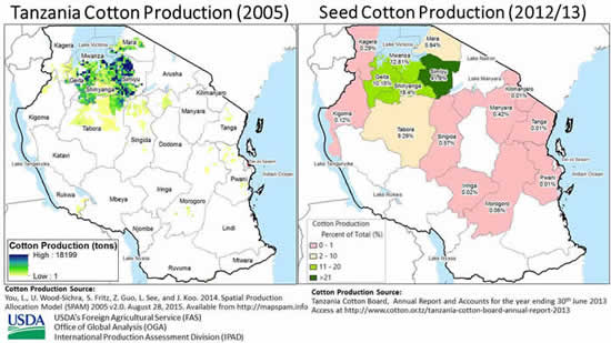
Figure 1 Tanzania’s major cotton production zone is located near Lake Victoria
Cotton is generally planted in northwestern Tanzania in December, with harvesting and marketing beginning in late June or early July. However, planting and harvesting seasons may vary, depending on low, intermediate or high seasonal rainfall (Figures 2 and 3). The local marketing year for Tanzanian cotton is from July 1st to June 30th and the marketing year as defined by USDA’s PSD Online is from August 1 to July 31.
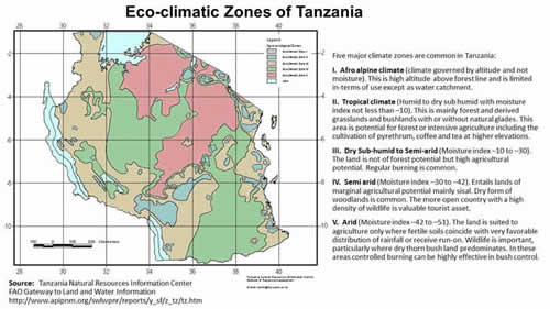
Figure 2. Five major eco-climates in Tanzania
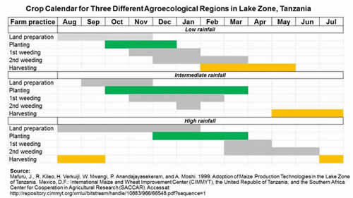
Figure 3. Crop calendar for low, intermediate and high rainfall regions located near Lake Victoria
Seasonal rainfall, temperature and soil moisture data from WMO (World Meteorological Organization) stations is available from USDA’s WMO Station Explorer. WMO Station #63756 at Mwanza, Tanzania is located within Tanzania’s major cotton belt and it was used as an indicator for monitoring seasonal rainfall for Tanzania’s major cotton region. As indicated in Figure 4, cumulative rainfall at Mwanza, Tanzania was near average during the planting season in December but was below average from January through April. Cumulative rainfall returned to normal from May to the end of the season, but the short term dryness during February and March greatly reduced 2015 cotton yields.
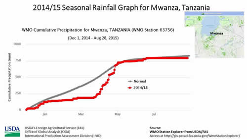
Figure 4. Seasonal rainfall at Mwanza, Tanzania was below average from January through April, 2015.
While WMO station analysis helps to monitor seasonal rainfall at point locations, utilizing satellite imagery is an excellent tool to monitor the vegetation growth response to rainfall across an area. USDA/FAS and NASA/GIMMS has developed a Global Agriculture Monitoring (GLAM) system which archives and displays 8-day NDVI (Normalized Difference Vegetation Index) composites obtained from the MODIS (Moderate Resolution Imaging Spectroradiometer) sensor onboard NASA’s Terra and Aqua satellites. Average NDVI values are calculated from the 8-day NDVI-MODIS imagery archive from 2000-2014 for MODIS-Terra imagery and from 2002-2014 for MODIS-Aqua imagery. Comparing average NDVI imagery with current NDVI composites enables crop analysts to easily monitor relative crop conditions for most regions worldwide.
The NDVI-MODIS anomaly image in Figure 5 shows that vegetation conditions were below average in mid-March for Tanzania’s cotton belt located south of Lake Victoria. The NDVI-MODIS anomaly image shown in Figure 5 was developed by subtracting NDVI values for March 14-21, 2015 from 2002-2014 average values, with below-average NDVI values (or drier than average vegetation) colored in light brown to red and above-average NDVI values (or greener than average vegetation) colored in light to dark green.
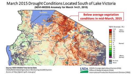
Figure 5. March 2015 Drought Conditions in Tanzania’s Cotton Belt Located South of Lake Victoria
The USDA/NASA NDVI-MODIS GLAM system can also extract NDVI values over cropland pixels within administrative regions to monitor the regional vegetation response to seasonal rainfall. Figure 6 displays the NDVI time series graph for Mwanza Region, Tanzania, and compares the current 2015 growing season with last year (i.e. 2014) and average (i.e., 2002-2014) growing seasons. The NDVI time series graph shown in Figure 6 indicates below-average vegetation vigor from mid-January through May, and corresponding 2015 cotton yields should be well below average.
Final conclusions are 2015 cotton yields in Tanzania should be below last year’s 2014 cotton yield of 169 kg/ha and well below the 5-year average yield of 189 kg/ha. Final cotton output figures will be determined after the crop is ginned by the end of this year or early next year.
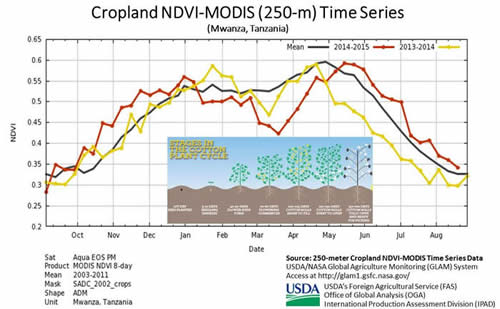
Figure 6. Cropland NDVI time series graphs from Mwanza, Tanzania
This report has been published by the Office of Global Analysis (OGA), International Production Assessment Division (IPAD). Current USDA area and production estimates for grains and other agricultural commodities are available at PSD Online. For more information contact Curt.Reynolds@fas.usda.gov.
Related USDA/FAS Web Links
Crop Explorer
http://www.pecad.fas.usda.gov/cropexplorer/Default.aspx
USDA/NASA GLAM (Global Agriculture Monitoring) System
http://glam1.gsfc.nasa.gov/
WMO Station Explorer
http://gis.pecad.fas.usda.gov/WmoStationExplorer/
PSD Online
http://apps.fas.usda.gov/psdonline/psdHome.aspx
|