IRAQ: Monitoring Lake Dahuk and the Mosul Dam with Satellite Radar
Iraq’s Lake Dahuk has been a very carefully watched body of water since the late 1980’s when it was created by the completion of the Mosul Dam on the Tigris River in northern Iraq about 10 kilometers north of the city of Mosul. The dam is the largest in Iraq and the fourth largest in the Middle East. The lake depends mainly on recharge from snowmelt in northeastern Turkey. Mosul Dam is the major source of hydroelectric power in Iraq while the lake provides much needed irrigation water for spring and summer crops. The dam was also built to help alleviate flooding in Baghdad from the Tigris River that commonly occurred during spring snowmelt.

In 2006, the Army Corp of Engineers reported Mosul Dam as one of the most dangerous in the world. One of the main concerns is the damage that would be inflicted if the dam failed. Flooding would extend down the Tigris, inundating the city of Mosul, and reaching as far as parts of Baghdad. The main problem is that the dam was constructed on top of gypsum, which dissolves in water. This inherent instability has led to ongoing remediation and rehabilitation efforts. One measure has been to lower the lake’s water level to help reduce pressure on the dam.
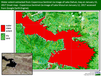
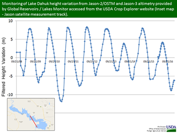
The Jason and Copernicus satellites provide repeated measurements of the lake based on radar instrumentation. Since radar imagery penetrates clouds, cloud cover is not an issue. Repeat times are every 10 days for Jason-3 and about every 6 days for Copernicus Sentinel-1. The Jason data is part of a joint, NASA-USDA Global Reservoirs / Lakes Monitoring program that can be accessed from the USDA Crop Explorer website (https://www.pecad.fas.usda.gov/cropexplorer/). The Copernicus data is provided by the European Space Agency and is available in Google Earth Engine (https://earthengine.google.com/). The Sentinel-1 data offer the ability to classify and measure the extent of the water surface area as a complement to the Jason-3 water height variation measurements.
Current USDA area and production estimates for grains and other agricultural commodities are available on IPAD's Agricultural Production page or at PSD Online.
Visit Crop Explorer http://www.pecad.fas.usda.gov/cropexplorer/
|