Cuba Rice: Satellite Imagery Monitors Irrigated Fields
Rice is an important staple crop for Cuba. USDA estimates Cuba‘s 2016/17 milled rice production at 433,000 metric tons, up 10 percent from last year but down from the peak of 465,000 tons in 2003/04.  Cuba’s main rice crop is planted in March and April and is harvested in November and December. While production is distributed relatively evenly across the country, the three main growing regions are Pinar del Rio, Sancti Spiritus, and Granma. Second-season rice is planted in December and January and harvested in June and July. Cuba’s main rice crop is planted in March and April and is harvested in November and December. While production is distributed relatively evenly across the country, the three main growing regions are Pinar del Rio, Sancti Spiritus, and Granma. Second-season rice is planted in December and January and harvested in June and July.
 Official statistics and ground observations are difficult to obtain from Cuba, so USDA analysts use other resources to estimate area, yield, and production of rice. These tools include moderate- and high-resolution satellite imagery to capture the flooding and draining of rice fields. Moderate-resolution satellites, like Landsat 8, can highlight the irrigated field networks in Cuba. In the Landsat 8 image of Pinar del Rio, the near-infrared, short-wave infrared, and visible red bands (5,6,4 band combination) can be used to identify irrigated fields. Commercially available high-resolution imagery, such as the World View satellites, can be used to confirm the location of rice fields. Official statistics and ground observations are difficult to obtain from Cuba, so USDA analysts use other resources to estimate area, yield, and production of rice. These tools include moderate- and high-resolution satellite imagery to capture the flooding and draining of rice fields. Moderate-resolution satellites, like Landsat 8, can highlight the irrigated field networks in Cuba. In the Landsat 8 image of Pinar del Rio, the near-infrared, short-wave infrared, and visible red bands (5,6,4 band combination) can be used to identify irrigated fields. Commercially available high-resolution imagery, such as the World View satellites, can be used to confirm the location of rice fields.
New satellites have also aided in this work, particularly the European Space Agency’s (ESA) Sentinel constellation. Sentinel 1a is a radar satellite with repeat coverage about every six days. Radar imagery penetrates cloud cover and is especially useful for countries in the Caribbean, such as Cuba, which are frequently cloudy during the growing season. The Sentinel 1a image of Granma, one of Cuba’s main rice growing regions, demonstrates the capability to map water bodies regardless of cloud cover. Satellite radar imagery is adept at monitoring water, including water in irrigated fields, water in streams and lakes, and water from flooding. The ability to examine flooded areas through the use of a variety of satellite resources enables USDA analysts to quickly and accurately assess the impact of natural disasters.
Cuban production accounts for nearly half of its total supplies, with the remainder being supplied by imports. For more information on Cuba’s imports see the featured rice story in the November 2016 Grain World Market and Trade Report.
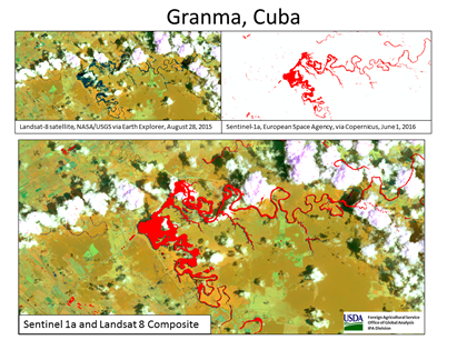
Figure 1: Radar satellite imagery (ESA Sentinel-1a) is overlaid on optical satellite imagery (NASA/USGS Landsat-8) to form a composite image which aids crop analysts to monitor water when it is cloudy.
Current USDA area and production estimates for grains and other agricultural commodities are available on IPAD's Agricultural Production page or at PSD Online.
Visit Crop Explorer http://www.pecad.fas.usda.gov/cropexplorer/
|