An Atypical Canadian Summer: Hot and Dry in the Prairies, Cool and Wet in the East
Analysts from the USDA Foreign Agricultural Service (FAS) conducted crop-assessment travel in Canada in July, meeting with farmers, cooperatives, non-profit organizations and government officials. The team 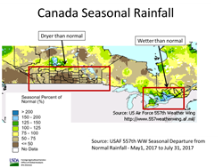 examined the shifting agricultural patterns in Canada and assessed the potential crop-production impacts of the heat and dryness in the Canadian Prairies and the cool, wet weather in Eastern Canada (see Figure 1). The National Geospatial Intelligence Agency’s MAGE mobile application was used to collect field data that will enable FAS analysts to create an in-season crop mask to improve area-estimation methods. examined the shifting agricultural patterns in Canada and assessed the potential crop-production impacts of the heat and dryness in the Canadian Prairies and the cool, wet weather in Eastern Canada (see Figure 1). The National Geospatial Intelligence Agency’s MAGE mobile application was used to collect field data that will enable FAS analysts to create an in-season crop mask to improve area-estimation methods.
Wheat, rapeseed, corn, barley, and soybeans are Canada’s main crops. Minor crops include sunflowers, rye, mixed grains and oats. Canada is the world’s second-largest producer of rapeseed, behind the European Union, with 2017/18 production forecast at 20.5 million metric tons. In 2017, for the first time, rapeseed area, estimated at 9.5 million hectares, surpassed the area sown to wheat, which has traditionally been Canada’s chief crop (see Figure 2). The decrease in wheat area from the high of 10.4 million hectares (mha) in 2013 to the current estimated area of 9.0 mha is due to several factors including a shift towards pulses and soybeans in the Prairies. Zero tillage, a common practice in the Prairies, is increasing the incidence of fusarium (a disease that harms wheat) and is another likely factor contributing to the decline of wheat area.
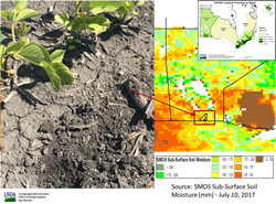
Wheat and rapeseed are the predominant crops in the Prairies and the crops have been negatively affected by hot and dry conditions during the growing season. High temperatures and low soil moisture in the main growing province of Saskatchewan (see Figure 3), which accounts for 50 percent of production for both wheat and rapeseed, led to the year-to-year decrease in estimated yields, as indicated by below-average NDVI (normalized difference vegetation index, a measure of vegetative vigor). The situation in Alberta was similar (see Figure 4). None of the Prairie Provinces (Alberta, Manitoba and Saskatchewan) received adequate rainfall during the critical growing stages for wheat and rapeseed.
 In recent years, soybeans have become an increasingly important crop in Canada, and production has expanded into the Prairie Provinces with some industry experts asserting that about a third of production now occurs in Manitoba. In addition to the expansion in Manitoba, soybeans are also planted as far west as eastern Saskatchewan. Since soybeans have a longer season than other crops, this push westward has benefited from the absence of an early frost for the last few years. With this expansion into the Prairies, soybeans are also impacted by the recent hot and dry conditions in Manitoba (see Figure 5). In recent years, soybeans have become an increasingly important crop in Canada, and production has expanded into the Prairie Provinces with some industry experts asserting that about a third of production now occurs in Manitoba. In addition to the expansion in Manitoba, soybeans are also planted as far west as eastern Saskatchewan. Since soybeans have a longer season than other crops, this push westward has benefited from the absence of an early frost for the last few years. With this expansion into the Prairies, soybeans are also impacted by the recent hot and dry conditions in Manitoba (see Figure 5).
 The crop season in Ontario and Quebec has been drastically different from the drier and hotter conditions of the Prairie Provinces. Ontario is having one of the rainiest summers on record, and crop development is estimated to be 2 to 4 weeks behind normal because of the rain. Ponding is a common sight in the corn and soybeans fields in eastern Canada and is the cause for area reduction for both crops (see Figure 6). Because of the excessive moisture, the estimated 2017/18 area for both corn and soybeans has been reduced slightly. The crop season in Ontario and Quebec has been drastically different from the drier and hotter conditions of the Prairie Provinces. Ontario is having one of the rainiest summers on record, and crop development is estimated to be 2 to 4 weeks behind normal because of the rain. Ponding is a common sight in the corn and soybeans fields in eastern Canada and is the cause for area reduction for both crops (see Figure 6). Because of the excessive moisture, the estimated 2017/18 area for both corn and soybeans has been reduced slightly.
USDA crop-production estimates for Canada and other countries area available at PSD Online.
The contributions of Erin Danielson, Jeff Zimmerman and Rhiannon Elms at the USDA Office of Agricultural Affairs in Ottawa are gratefully acknowledged.
Figure 2:

Figure 3:

Figure 4:

Current USDA area and production estimates for grains and other agricultural commodities are available on IPAD's Agricultural Production page or at PSD Online.
Visit Crop Explorer http://www.pecad.fas.usda.gov/cropexplorer/
|