Flooding in Central China - Huai River Basin
Heavy rain since mid-June has caused serious flooding and water logging in many parts of central China. According to local sources, as of mid-July more than 5.5 million hectares of cropland have been affected in 6 provinces (Anhui, Hubei, Henan, Jiangsu, Shaanxi, and Sichuan). More than 400 people have died and about 3.19 million have been displaced. Economic losses are estimated at $4.25 billion dollars. Some analysts have described the current flooding along the Huai River as the worst in 50 years.
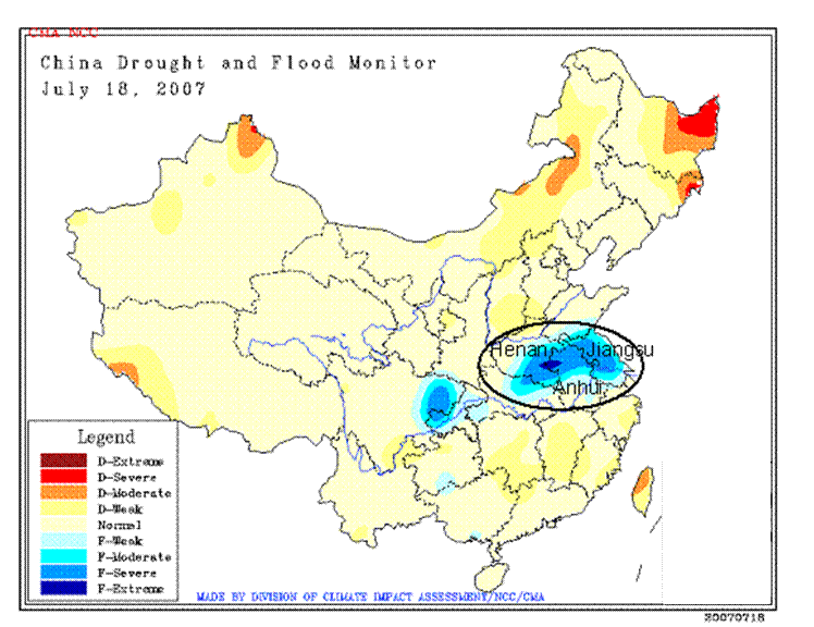
The most serious flooding has occurred in the Huai River basin, located in eastern China between the Yellow River in the north and Yangtze River in the south. (Map) It was generally dry in early June (favoring winter wheat and rapeseed harvesting and summer crop planting. Near normal rainfall from June 20-31 favored germination and emergence. Since July 1, more than 300 mm (12 inches) of rain has fallen over most of the region (2x to 3x above normal) and the weather forecast calls for more rain this week (through July 21). Soils are saturated and water levels in rivers and reservoirs are above the warning stage.
Satellite Imagery
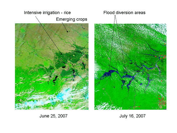
A comparison of MODIS satellite imagery from June 25, 2007 (before the onset of the heavy rain) with July 16, 2007 clearly shows the massive changes in water level within the basin. The Huai River and its tributaries are barely visible on the June 25 image, and there is a clear distinction between irrigated rice (dark green), emerging rain-fed summer crops in the north (pale green/tan) and spring crops/natural vegetation (bright green) in the south. The subsequent image (July 16) highlights the impact that three weeks of heavy rain can have on a river system. The main channel and all tributaries are flowing at capacity, reservoirs are full, and water is covering large tracts of land in the upper part of the basin.
This same area received above normal rainfall in July 2006, but total amounts were smaller and satellite imagery shows that flooding was not a problem.
Flood Control
The Huai River runs west to east across central China, passing through Henan and Anhui provinces. It has a length of 1,078 kilometers and a drainage area of 174,000 square kilometers. The river has changed its course many times over the years and no longer flows into the Pacific Ocean, ending instead in Lake Hongze (in Jiangsu province). The major summer crops grown in the Huai River basin include single crop rice, corn, and cotton.
Flooding is very common in this part of the country during the summer, and the Chinese have developed an elaborate and highly efficient water management system of canals, dikes, reservoirs, and water gates to cope with the problem. China has designated 7 water diversion zones, low-lying areas in the upper and middle reaches of the basin where excess water is diverted to prevent catastrophic flooding downstream. More than 100,000 hectares of cropland have already been deliberately flooded, and the Chinese are prepared to open up more diversion areas and take whatever measures are necessary to protect the cities and infrastructure. These efforts have been generally successful: three flood crests have safely passed down the river without causing significant damage.
Crop Impact is Uncertain
It is too early to measure the impact of the Huai basin flooding on crop production, but some general assumptions can be made. Additional planted area could be lost if more flood diversions are necessary. Cotton is particularly vulnerable to water logging and is likely to be disproportionately affected. Replanting with short season (lower-yielding) crops will be necessary in the diversion areas, which must first be drained. Summer crops are now in the vegetative stage, with reproduction normally occurring in late-July/early August. Although the single rice crop should be able to cope with the excess water without difficulty, the cooler temperatures and cloudiness could have a negative yield impact. In contrast, the abundant rainfall could have a positive impact on corn and other summer crop yields in areas not directly affected by flooding.
Current USDA area and production estimates for grains and other agricultural commodities are available on PECAD's Agricultural Production page or at PSD Online.
|