Kenya: Below-Average Corn Output Expected
USDA’s August forecast for Kenya’s 2008/09 corn production is 2.55 million tons, down 0.4 million tons from last year and below the 5-year average of 2.7 million tons. Area is estimated at 1.6 million hectares, down 0.1 million hectares from last year due to insecurity caused by Post-Election Violence (PEV) from January-April this year. The forecast yield is 1.59 tons per hectare which is same as the 5-year average. USDA’s forecast yield could be adjusted later this year as the "long rains" season progresses further and after the "short rains" crop is planted in October. Final national yields will be dependent on rainfall received during the remainder of the long rains and short rains seasons, and long rains yields could be reduced due to drought in several parts of the country, late-plantings especially in Rift Valley province caused by PEV, and less fertilizer applied due to very high fertilizer prices.
USDA’s Foreign Agricultural Service (FAS) and USAID’s FEWS NET project conducted a crop assessment tour from June 30-July 3, 2008, and the crop assessment route is shown in Figure 1. The survey team transected Kenya's four major grain-producing provinces, namely Rift Valley, Western, Nyanza, and Central provinces. The team visited four Ministry of Agriculture (MoA) provincial headquarters and these MoA offices provided the survey team with preliminary crop production reports for the "long rains" season. Additional interviews and data were collected which helped to determine USDA’s August crop production forecast. Summary statistics collected from Kenya’s MoA are presented in Table 1, whereby the four provinces visited produce nearly 95 percent of Kenya’s total long rains output and 85 percent of the total national output. Kenya’s “long rains” season is from March through December and the “short rains” season is from October to February.
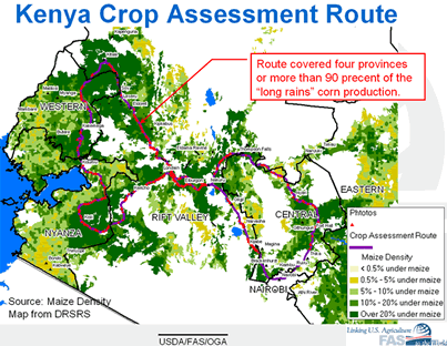
Figure 1. 2008 Crop Assessment Route
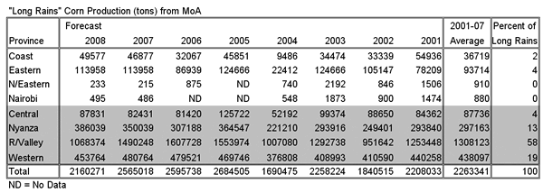
Table 1. Historical"long rains" production with current 2008/09 forecast
Kenya is divided into eight provinces and these provincial boundaries have not changed for several decades. But new districts were created last year which more than doubled the total number of Kenya districts from 71 to 148 districts. Many of these new districts have not yet been properly defined or delineated which causes problems in compiling crop statistics at the district level for this year. In addition, the top seven producing districts from the old 71 district system were informally know as the “Big 7” districts and comprised of Trans Nzoia, Uasin Gishu, Kericho, Nandi and Nakuru districts in Rift Valley province; and Bungoma and Lugari districts in Western province (see Figure 2). However, the “Big 7” districts have now been divided into more numerous and smaller districts, which makes district analysis in Kenya even more difficult. USDA/FAS, therefore, only performs historical crop yield analysis at the provincial level because the provincial boundaries for MoA crop statistics have not changed for several decades (refer to USDA's MODIS-NDVI database).
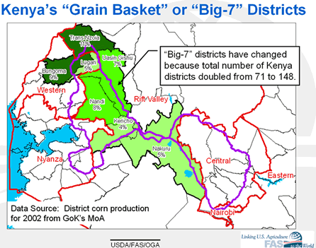
Figure 2. Former "Big-7" Districts within Kenya's "Grain Basket"
It was also noted by the survey team and MoA offices that farming in Kenya has become more advanced in recent years, especially within the northern Big-7 districts. For example, district data from Trans Nzoia compared to national yields are shown in Figure 3 and illustrate how corn yields in the districtdoubled during the past 5-years while national yields have not improved much over the past 15-years. Several reasons for improved yields in Trans Nzoia district include (see Figure 4):
- More agricultural extension provided by Kenya's MoA after Agricultural Reform implementation in 2003.
- More seed companies, better hybrids (i.e., double cobs per stalk), and greater effort to plant optimal plant density populations.
- Improved soil testing for optimal fertilizer applications.
- Better control for disease and pests.
-
Less post-harvest losses.
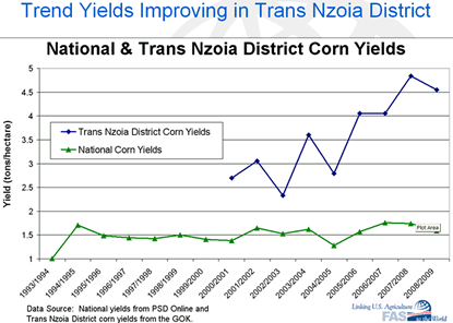
Figure 3. National Yields Compared to Trans Nzoia District Yields
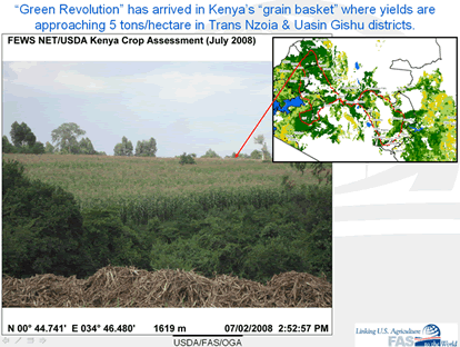
Figure 4. Green Revolution in Trans Nzoia District
Seasonal Summary
The “long rains” arrived a few weeks late in some parts of Kenya but seasonal rains were favorable in Kenya’s main grain basket, or the highland regions of the Big-7 districts (see Figure 5). The percent of normal seasonal rainfall from February 1 through August 24, 2008 is shown in Figure 5, and indicates Kenya's grain basket received near-average seasonal rainfall, and Kenya's Central province and lowlands of the Rift Valley received below-average rainfall. Rainfall and NDVI-SPOT VEG time series also indicate that the rains started a few weeks late in Central province and June rainfall for this region was well below-average.
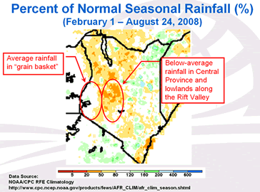
Figure 5. Percent of Normal Seasonal Rainfall from February 1 through August 4, 2008
Crop stage for Rift Valley province in early July ranged from vegetative to tasseling in the highland areas, and tasseling to grain-filling in the lowland regions. Crop stage was most advanced in Nyanza province where green corn was beginning to be harvested and sold in local markets. Crop stage in Central province was also advanced and ranged from tasseling to grain-filling, but crop conditions were very poor in the lowland regions of Central province, where 60 percent of the crop was estimated by the MoA to have failed. MoA officials in Central Province reported that below-average rainfall during June severely damaged the crop which was in the critical silking and tasseling stages at the time. Correspondingly, the MODIS NDVI anomaly image for July 26th shows below-average crop conditions throughout most of the lowlands of Rift Valley and Central provinces, but near-average crop conditions within the highlands of the Rift Valley grain basket (see Figure 6). Crop NDVI-MODIS time series plots also show below-average profiles during the dry month of June, but NDVI or vegetation conditions responded favorably to average rainfall during the months of July and August.
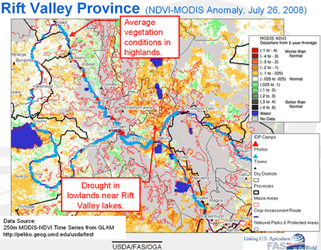
Figure 6. MODIS-NDVI Anomaly Image Showing Average
Vegetation Conditions within the "Grain Basket" at end of July, 2008
Post-Election Violence (PEV)
Post-Election Violence (PEV) was a term commonly used by the Government of Kenya (GoK) to describe the political turmoil that Kenyans experienced after elections on December 27, 2007 and until a unity government was sworn into power on April 17, 2008. During this four month period of PEV, numerous shops in small towns and rural farms were specifically targeted, looted, and often burned to the ground simply because the owners or inhabitants were from different ethnic groups or perceived to support a particular political party. Fear prevailed in many rural areas during this four month period, especially in transition zones where two or more different ethnic groups reside. Many families living within tribal transition regions were forced from their homes or farms, and nearby Internally Displaced Person (IDP) camps were established to provide temporary housing facilities for PEV victims and families. Several IDP camps still existed during our visit and numerous shops, houses, and businesses were found with only burnt foundations or walls remaining (see Figure 7). The epicenter of the PEV activities appeared to occur between Nakuru and Eldoret towns, where the survey team observed the most numerous concentration of IDP camps, burnt homes and shops (Figure 8).
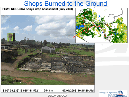
Figure 7. Shops Burned to the Ground, north of Nakuru town
It was reported by the MoA offices that when the rains arrived in March, many farmers were still afraid to plant and they did not believe growing a crop was worth the risk (see Figure 9). However, by the time the unity government accord was signed by April 17th, many farmers decided to plant a late corn crop, or plant wheat if they had that option. In addition, the government provided free seeds to the inhabitants within IDP camps as an incentive to encourage IDP dwellers to return to their farms and homes. Many farms between Nakuru and Eldoret towns were still abandoned by the time we visited in early July, but many farmers living in the higher elevations were in the process of planting wheat, instead of corn, because the corn planting season was over but it was not too late to plant wheat (see Figure 10).

Figure 8. Region of Post Election Violence
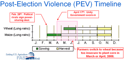
Figure 9. Post-Election Violence (PEV) Timeline
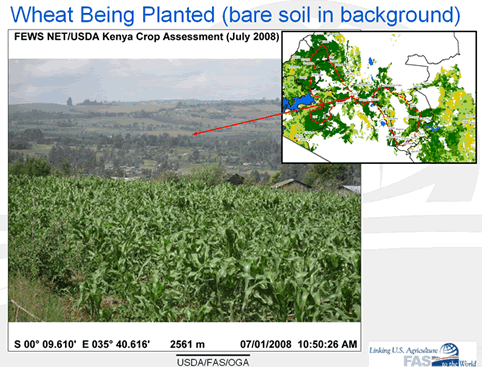
Figure 10. Wheat being planted in July (bare soil in the background)
Country Summary
Kenya is having a very difficult agricultural season this year due delayed plantings caused by four months of Post-Election Violence (PEV) from January to April, high fertilizer prices, and less than favorable rains in the Central Province and the lowlands along the Rift Valley. However, crop conditions within the Big-7 districts were good due to favorable seasonal rainfall in the grain basket, but fertilizer applications were reported to be less than optimal throughout the country due to high fertilizer prices. Luckily, rainfall has not been excessive this year which helped prevent expensive fertilizers from being leached away. Another popular management practice this year was to use more animal manure as an alternative to extremely expensive fertilizers. Current USDA forecast yields could be revised later this year and yields could be reduced due to drought in several parts of the country, late-plantings especially in Rift Valley province caused by PEV, and less fertilizers applied countrywide due to very high fertilizer prices.
Other Related Links from FAS
OGA's Geo-referenced Photo Gallery for Kenya
Crop Explorer (for East Africa)
Crop-NDVI-MODIS Time Series Data
Daily MODIS (250-meter resolution) Satellite Images over Africa
MODIS-NDVI (250-meter resolution) Time Series Data
Rainfall and NDVI-SPOT Veg (1-kilometer resolution) Time Series Data
Summary Figures from 2008 Crop Assessment
Kenya's Agro-ecological Zones
Kenya's District-Level Corn Production for Long-Rain and Short-Rain Seasons
Crop Calendar for Kenya
2004 Kenya Crop Assessment (October 25-30, 2004)
Different Crops Grown in Kenya
Tea Plantations in Kenya
Current USDA area and production estimates for grains and other agricultural commodities are available at PSD Online.
|