IPAD
International
Production
Assessment
Division
Toggle navigation
Reports and Briefs
Commodity Intelligence Reports (CIR)
World Agricultural Production (WAP) Circulars
Geospatial Data
Crop Explorer
Commodity Explorer
Global Agricultural Monitoring (GLAM)
Global Reservoirs and Lakes Monitor (G-REALM)
Global Agricultural & Disaster Assesment System (GADAS)
Geotag Photo Gallery
Tropical Cyclone Monitor
WMO Station Explorer
Crop Calendars and Production Maps
Country Summary
Crop Calendars
Crop Production Maps
Monthly Crop Stage and Harvest Calendars
Monthly Production and Trade Maps
Other Global USDA Reports
World Agricultural Supply and Demand Estimates (WASDE)
USDA Weekly Weather and Crop Bulletin (NASS/WAOB)
PSD Online
FAS Attache GAIN Reports
PS&D Market and Trade Data
Help
About Us
FAS Home
/
IPAD Home
/
Crop Explorer
/
Commodity Explorer
/
Rice Explorer
/
Egypt
Rice Explorer
Toolbox
Home
Return to Commodity Page
Most Recent Data
Country
European Union
Algeria
Argentina
Armenia
Australia
Azerbaijan
Belarus
Brazil
Chile
China
Ethiopia
India
Iran
Iraq
Japan
Kazakhstan
Kyrgyzstan
Libya
Mexico
Moldova
Morocco
North Macedonia
Peru
Russia
Serbia
South Africa
South Korea
Switzerland
Syria
Tajikistan
Tunisia
Turkey
Ukraine
United States
Uruguay
Uzbekistan
Precipitation
Moving Precipitation and Cumulative Precipitation (Pentad)
Temperature
Average Temperature
Maximum Temperature
Minimum Temperature
Soil Moisture
Soil Moisture (CPC Leaky Bucket)
Percent Soil Moisture
Surface Soil Moisture
Subsurface Soil Moisture
Vegetation Index
NDVI (MODIS-Terra)
Additional Resources
Area, Yield and Production
WAP Production Briefs
Commodity Intelligence Reports
Country Summary
Geotag Photo Gallery
Crop Calendar
Crop Production Maps
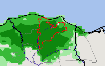
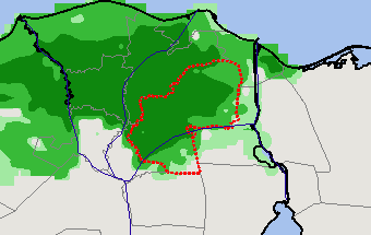
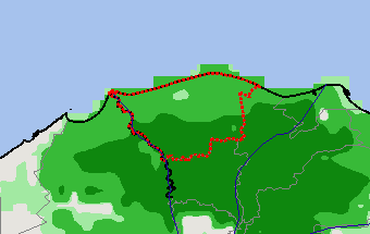
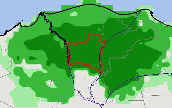
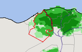
Rice Production
2021 Spring Crop (Mar - Feb) — (Last Chart Updated on )
Subregions:
Select a Subregion
Ad Daqahliyah
Ash Sharqiyah
Kafr ash Shaykh
Al Gharbiyah
Al Buhayrah
Ad Daqahliyah
(32% of total rice production)
Ash Sharqiyah
(16% of total rice production)
Kafr ash Shaykh
(14% of total rice production)
Al Gharbiyah
(14% of total rice production)
Al Buhayrah
(13% of total rice production)
Stay Connected
FAS on Twitter
Get Email Updates
FAS Home
USDA.gov
Economic Research Service
World Agricultural Outlook Board
Plain Writing
Trade Links
FOIA
Accessibility Statement
Privacy Policy
Non Discrimination Statement
Information Quality
USA.gov
White House